Sunday, September 25, 2005


Natural hazards


Afghanistan


damaging earthquakes occur in Hindu Kush mountains; flooding; droughts


Albania


destructive earthquakes; tsunamis occur along southwestern coast; floods; drought


Algeria


mountainous areas subject to severe earthquakes; mudslides and floods in rainy season


American Samoa


typhoons common from December to March


Andorra


avalanches


Angola


locally heavy rainfall causes periodic flooding on the plateau


Anguilla


frequent hurricanes and other tropical storms (July to October)


Antarctica


katabatic (gravity-driven) winds blow coastward from the high interior; frequent blizzards form near the foot of the plateau; cyclonic storms form over the ocean and move clockwise along the coast; volcanism on Deception Island and isolated areas of West Antarctica; other seismic activity rare and weak; large icebergs may calve from ice shelf


Antigua and Barbuda


hurricanes and tropical storms (July to October); periodic droughts


Arctic Ocean


ice islands occasionally break away from northern Ellesmere Island; icebergs calved from glaciers in western Greenland and extreme northeastern Canada; permafrost in islands; virtually ice locked from October to June; ships subject to superstructure icing from October to May


Argentina


San Miguel de Tucuman and Mendoza areas in the Andes subject to earthquakes; pamperos are violent windstorms that can strike the Pampas and northeast; heavy flooding


Armenia


occasionally severe earthquakes; droughts


Aruba


lies outside the Caribbean hurricane belt


Ashmore and Cartier Islands


surrounded by shoals and reefs that can pose maritime hazards


Atlantic Ocean


icebergs common in Davis Strait, Denmark Strait, and the northwestern Atlantic Ocean from February to August and have been spotted as far south as Bermuda and the Madeira Islands; ships subject to superstructure icing in extreme northern Atlantic from October to May; persistent fog can be a maritime hazard from May to September; hurricanes (May to December)


Australia


cyclones along the coast; severe droughts; forest fires


Austria


landslides; avalanches; earthquakes


Azerbaijan


droughts


Bahamas, The


hurricanes and other tropical storms cause extensive flood and wind damage


Bahrain


periodic droughts; dust storms


Baker Island


the narrow fringing reef surrounding the island can be a maritime hazard


Bangladesh


droughts, cyclones; much of the country routinely inundated during the summer monsoon season


Barbados


infrequent hurricanes; periodic landslides


Bassas da India


maritime hazard since it is usually under water during high tide and surrounded by reefs; subject to periodic cyclones


Belarus


NA


Belgium


flooding is a threat in areas of reclaimed coastal land, protected from the sea by concrete dikes


Belize


frequent, devastating hurricanes (June to November) and coastal flooding (especially in south)


Benin


hot, dry, dusty harmattan wind may affect north from December to March


Bermuda


hurricanes (June to November)


Bhutan


violent storms from the Himalayas are the source of the country's name which translates as Land of the Thunder Dragon; frequent landslides during the rainy season


Bolivia


flooding in the northeast (March-April)


Bosnia and Herzegovina


destructive earthquakes


Botswana


periodic droughts; seasonal August winds blow from the west, carrying sand and dust across the country, which can obscure visibility


Bouvet Island


NA


Brazil


recurring droughts in northeast; floods and occasional frost in south


British Indian Ocean Territory


NA


British Virgin Islands


hurricanes and tropical storms (July to October)


Brunei


typhoons, earthquakes, and severe flooding are very rare


Bulgaria


earthquakes, landslides


Burkina Faso


recurring droughts


Burma


destructive earthquakes and cyclones; flooding and landslides common during rainy season (June to September); periodic droughts


Burundi


flooding, landslides, drought


Cambodia


monsoonal rains (June to November); flooding; occasional droughts


Cameroon


volcanic activity with periodic releases of poisonous gases from Lake Nyos and Lake Monoun volcanoes


Canada


continuous permafrost in north is a serious obstacle to development; cyclonic storms form east of the Rocky Mountains, a result of the mixing of air masses from the Arctic, Pacific, and North American interior, and produce most of the country's rain and snow east of the mountains


Cape Verde


prolonged droughts; seasonal harmattan wind produces obscuring dust; volcanically and seismically active


Cayman Islands


hurricanes (July to November)


Central African Republic


hot, dry, dusty harmattan winds affect northern areas; floods are common


Chad


hot, dry, dusty harmattan winds occur in north; periodic droughts; locust plagues


Chile


severe earthquakes; active volcanism; tsunamis


China


frequent typhoons (about five per year along southern and eastern coasts); damaging floods; tsunamis; earthquakes; droughts; land subsidence


Christmas Island


the narrow fringing reef surrounding the island can be a maritime hazard


Clipperton Island


NA


Cocos (Keeling) Islands


cyclone season is October to April


Colombia


highlands subject to volcanic eruptions; occasional earthquakes; periodic droughts


Comoros


cyclones possible during rainy season (December to April); Le Kartala on Grand Comore is an active volcano


Congo, Democratic Republic of the


periodic droughts in south; Congo River floods (seasonal); in the east, in the Great Rift Valley, there are active volcanoes


Congo, Republic of the


seasonal flooding


Cook Islands


typhoons (November to March)


Coral Sea Islands


occasional tropical cyclones


Costa Rica


occasional earthquakes, hurricanes along Atlantic coast; frequent flooding of lowlands at onset of rainy season and landslides; active volcanoes


Cote d'Ivoire


coast has heavy surf and no natural harbors; during the rainy season torrential flooding is possible


Croatia


destructive earthquakes


Cuba


the east coast is subject to hurricanes from August to October (in general, the country averages about one hurricane every other year); droughts are common


Cyprus


moderate earthquake activity; droughts


Czech Republic


flooding


Denmark


flooding is a threat in some areas of the country (e.g., parts of Jutland, along the southern coast of the island of Lolland) that are protected from the sea by a system of dikes


Djibouti


earthquakes; droughts; occasional cyclonic disturbances from the Indian Ocean bring heavy rains and flash floods


Dominica


flash floods are a constant threat; destructive hurricanes can be expected during the late summer months


Dominican Republic


lies in the middle of the hurricane belt and subject to severe storms from June to October; occasional flooding; periodic droughts


East Timor


floods and landslides are common; earthquakes, tsunamis, tropical cyclones


Ecuador


frequent earthquakes, landslides, volcanic activity; floods; periodic droughts


Egypt


periodic droughts; frequent earthquakes, flash floods, landslides; hot, driving windstorm called khamsin occurs in spring; dust storms, sandstorms


El Salvador


known as the Land of Volcanoes; frequent and sometimes very destructive earthquakes and volcanic activity; extremely susceptible to hurricanes


Equatorial Guinea


violent windstorms, flash floods


Eritrea


frequent droughts; locust swarms


Estonia


sometimes flooding occurs in the spring


Ethiopia


geologically active Great Rift Valley susceptible to earthquakes, volcanic eruptions; frequent droughts


Europa Island


NA


Falkland Islands (Islas Malvinas)


strong winds persist throughout the year


Faroe Islands


NA


Fiji


cyclonic storms can occur from November to January


Finland


NA


France


flooding; avalanches; midwinter windstorms; drought; forest fires in south near the Mediterranean


French Guiana


high frequency of heavy showers and severe thunderstorms; flooding


French Polynesia


occasional cyclonic storms in January


French Southern and Antarctic Lands


Ile Amsterdam and Ile Saint-Paul are extinct volcanoes


Gabon


NA


Gambia, The


drought (rainfall has dropped by 30% in the last 30 years)


Gaza Strip


droughts


Georgia


earthquakes


Germany


flooding


Ghana


dry, dusty, northeastern harmattan winds occur from January to March; droughts


Gibraltar


NA


Glorioso Islands


periodic cyclones


Greece


severe earthquakes


Greenland


continuous permafrost over northern two-thirds of the island


Grenada


lies on edge of hurricane belt; hurricane season lasts from June to November


Guadeloupe


hurricanes (June to October); Soufriere de Guadeloupe is an active volcano


Guam


frequent squalls during rainy season; relatively rare, but potentially very destructive typhoons (June - December)


Guatemala


numerous volcanoes in mountains, with occasional violent earthquakes; Caribbean coast extremely susceptible to hurricanes and other tropical storms


Guernsey


NA


Guinea


hot, dry, dusty harmattan haze may reduce visibility during dry season


Guinea-Bissau


hot, dry, dusty harmattan haze may reduce visibility during dry season; brush fires


Guyana


flash floods are a constant threat during rainy seasons


Haiti


lies in the middle of the hurricane belt and subject to severe storms from June to October; occasional flooding and earthquakes; periodic droughts


Heard Island and McDonald Islands


Mawson Peak, an active volcano, is on Heard Island


Holy See (Vatican City)


NA


Honduras


frequent, but generally mild, earthquakes; extremely susceptible to damaging hurricanes and floods along the Caribbean coast


Hong Kong


occasional typhoons


Howland Island


the narrow fringing reef surrounding the island can be a maritime hazard


Iceland


earthquakes and volcanic activity


India


droughts; flash floods, as well as widespread and destructive flooding from monsoonal rains; severe thunderstorms; earthquakes


Indian Ocean


occasional icebergs pose navigational hazard in southern reaches


Indonesia


occasional floods, severe droughts, tsunamis, earthquakes, volcanoes, forest fires


Iran


periodic droughts, floods; dust storms, sandstorms; earthquakes along western border and in the northeast


Iraq


dust storms, sandstorms, floods


Ireland


NA


Israel


sandstorms may occur during spring and summer; droughts; periodic earthquakes


Italy


regional risks include landslides, mudflows, avalanches, earthquakes, volcanic eruptions, flooding; land subsidence in Venice


Jamaica


hurricanes (especially July to November)


Jan Mayen


dominated by the volcano Haakon VII Toppen/Beerenberg; volcanic activity resumed in 1970


Japan


many dormant and some active volcanoes; about 1,500 seismic occurrences (mostly tremors) every year; tsunamis; typhoons


Jarvis Island


the narrow fringing reef surrounding the island poses a maritime hazard


Jersey


NA


Johnston Atoll


NA


Jordan


droughts; periodic earthquakes


Juan de Nova Island


periodic cyclones


Kazakhstan


earthquakes in the south, mudslides around Almaty


Kenya


recurring drought; flooding during rainy seasons


Kingman Reef


wet or awash most of the time, maximum elevation of about 1 meter makes Kingman Reef a maritime hazard


Kiribati


typhoons can occur any time, but usually November to March; occasional tornadoes; low level of some of the islands make them very sensitive to changes in sea level


Korea, North


late spring droughts often followed by severe flooding; occasional typhoons during the early fall


Korea, South


occasional typhoons bring high winds and floods; low-level seismic activity common in southwest


Kuwait


sudden cloudbursts are common from October to April; they bring heavy rain which can damage roads and houses; sandstorms and dust storms occur throughout the year, but are most common between March and August


Kyrgyzstan


NA


Laos


floods, droughts


Latvia


NA


Lebanon


dust storms, sandstorms


Lesotho


periodic droughts


Liberia


dust-laden harmattan winds blow from the Sahara (December to March)


Libya


hot, dry, dust-laden ghibli is a southern wind lasting one to four days in spring and fall; dust storms, sandstorms


Liechtenstein


NA


Lithuania


NA


Luxembourg


NA


Macau


typhoons


Macedonia, The Former Yugoslav Republic of


high seismic risks


Madagascar


periodic cyclones


Malawi


NA


Malaysia


flooding, landslides, forest fires


Maldives


low level of islands makes them very sensitive to sea level rise


Mali


hot, dust-laden harmattan haze common during dry seasons; recurring droughts; occasional Niger River flooding


Malta


NA


Man, Isle of


NA


Marshall Islands


infrequent typhoons


Martinique


hurricanes, flooding, and volcanic activity (an average of one major natural disaster every five years)


Mauritania


hot, dry, dust/sand-laden sirocco wind blows primarily in March and April; periodic droughts


Mauritius


cyclones (November to April); almost completely surrounded by reefs that may pose maritime hazards


Mayotte


cyclones during rainy season


Mexico


tsunamis along the Pacific coast, volcanoes and destructive earthquakes in the center and south, and hurricanes on the Pacific, Gulf of Mexico, and Caribbean coasts


Micronesia, Federated States of


typhoons (June to December)


Midway Islands


NA


Moldova


landslides (57 cases in 1998)


Monaco


NA


Mongolia


dust storms, grassland and forest fires, drought, and "zud", which is harsh winter conditions


Montserrat


severe hurricanes (June to November); volcanic eruptions (Soufriere Hills volcano has erupted continuously since 1996)


Morocco


northern mountains geologically unstable and subject to earthquakes; periodic droughts


Mozambique


severe droughts; devastating cyclones and floods occur in central and southern provinces


Namibia


prolonged periods of drought


Nauru


periodic droughts


Navassa Island


NA


Nepal


severe thunderstorms, flooding, landslides, drought, and famine depending on the timing, intensity, and duration of the summer monsoons


Netherlands


flooding


Netherlands Antilles


Curacao and Bonaire are south of Caribbean hurricane belt and are rarely threatened; Sint Maarten, Saba, and Sint Eustatius are subject to hurricanes from July to October


New Caledonia


cyclones, most frequent from November to March


New Zealand


earthquakes are common, though usually not severe; volcanic activity


Nicaragua


destructive earthquakes, volcanoes, landslides; extremely susceptible to hurricanes


Niger


recurring droughts


Nigeria


periodic droughts; flooding


Niue


typhoons


Norfolk Island


typhoons (especially May to July)


Northern Mariana Islands


active volcanoes on Pagan and Agrihan; typhoons (especially August to November)


Norway


rockslides, avalanches


Oman


summer winds often raise large sandstorms and dust storms in interior; periodic droughts


Pacific Ocean


surrounded by a zone of violent volcanic and earthquake activity sometimes referred to as the "Pacific Ring of Fire"; subject to tropical cyclones (typhoons) in southeast and east Asia from May to December (most frequent from July to October); tropical cyclones (hurricanes) may form south of Mexico and strike Central America and Mexico from June to October (most common in August and September); cyclical El Nino/La Nina phenomenon occurs in the equatorial Pacific, influencing weather in the Western Hemisphere and the western Pacific; ships subject to superstructure icing in extreme north from October to May; persistent fog in the northern Pacific can be a maritime hazard from June to December


Pakistan


frequent earthquakes, occasionally severe especially in north and west; flooding along the Indus after heavy rains (July and August)


Palau


typhoons (June to December)


Palmyra Atoll


NA


Panama


occasional severe storms and forest fires in the Darien area


Papua New Guinea


active volcanism; situated along the Pacific "Ring of Fire"; the country is subject to frequent and sometimes severe earthquakes; mud slides; tsunamis


Paracel Islands


typhoons


Paraguay


local flooding in southeast (early September to June); poorly drained plains may become boggy (early October to June)


Peru


earthquakes, tsunamis, flooding, landslides, mild volcanic activity


Philippines


astride typhoon belt, usually affected by 15 and struck by five to six cyclonic storms per year; landslides; active volcanoes; destructive earthquakes; tsunamis


Pitcairn Islands


typhoons (especially November to March)


Poland


flooding


Portugal


Azores subject to severe earthquakes


Puerto Rico


periodic droughts; hurricanes


Qatar


haze, dust storms, sandstorms common


Reunion


periodic, devastating cyclones (December to April); Piton de la Fournaise on the southeastern coast is an active volcano


Romania


earthquakes, most severe in south and southwest; geologic structure and climate promote landslides


Russia


permafrost over much of Siberia is a major impediment to development; volcanic activity in the Kuril Islands; volcanoes and earthquakes on the Kamchatka Peninsula


Rwanda


periodic droughts; the volcanic Virunga mountains are in the northwest along the border with Democratic Republic of the Congo


Saint Helena


active volcanism on Tristan da Cunha


Saint Kitts and Nevis


hurricanes (July to October)


Saint Lucia


hurricanes and volcanic activity


Saint Pierre and Miquelon


persistent fog throughout the year can be a maritime hazard


Saint Vincent and the Grenadines


hurricanes; Soufriere volcano on the island of Saint Vincent is a constant threat


Samoa


occasional typhoons; active volcanism


San Marino


NA


Sao Tome and Principe


NA


Saudi Arabia


frequent sand and dust storms


Senegal


lowlands seasonally flooded; periodic droughts


Seychelles


lies outside the cyclone belt, so severe storms are rare; short droughts possible


Sierra Leone


dry, sand-laden harmattan winds blow from the Sahara (December to February); sandstorms, dust storms


Singapore


NA


Slovakia


NA


Slovenia


flooding and earthquakes


Solomon Islands


typhoons, but rarely destructive; geologically active region with frequent earth tremors; volcanic activity


Somalia


recurring droughts; frequent dust storms over eastern plains in summer; floods during rainy season


South Africa


prolonged droughts


South Georgia and the South Sandwich Islands


the South Sandwich Islands have prevailing weather conditions that generally make them difficult to approach by ship; they are also subject to active volcanism


Southern Ocean


huge icebergs with drafts up to several hundred meters; smaller bergs and iceberg fragments; sea ice (generally 0.5 to 1 meter thick) with sometimes dynamic short-term variations and with large annual and interannual variations; deep continental shelf floored by glacial deposits varying widely over short distances; high winds and large waves much of the year; ship icing, especially May-October; most of region is remote from sources of search and rescue


Spain


periodic droughts


Spratly Islands


typhoons; serious maritime hazard because of numerous reefs and shoals


Sri Lanka


occasional cyclones and tornadoes


Sudan


dust storms and periodic persistent droughts


Suriname


NA


Svalbard


ice floes often block the entrance to Bellsund (a transit point for coal export) on the west coast and occasionally make parts of the northeastern coast inaccessible to maritime traffic


Swaziland


drought


Sweden


ice floes in the surrounding waters, especially in the Gulf of Bothnia, can interfere with maritime traffic


Switzerland


avalanches, landslides, flash floods


Syria


dust storms, sandstorms


Taiwan


earthquakes and typhoons


Tajikistan


earthquakes and floods


Tanzania


flooding on the central plateau during the rainy season; drought


Thailand


land subsidence in Bangkok area resulting from the depletion of the water table; droughts


Togo


hot, dry harmattan wind can reduce visibility in north during winter; periodic droughts


Tokelau


lies in Pacific typhoon belt


Tonga


cyclones (October to April); earthquakes and volcanic activity on Fonuafo'ou


Trinidad and Tobago


outside usual path of hurricanes and other tropical storms


Tromelin Island


NA


Tunisia


NA


Turkey


very severe earthquakes, especially in northern Turkey, along an arc extending from the Sea of Marmara to Lake Van


Turkmenistan


NA


Turks and Caicos Islands


frequent hurricanes


Tuvalu


severe tropical storms are usually rare, but, in 1997, there were three cyclones; low level of islands make them very sensitive to changes in sea level


Uganda


NA


Ukraine


NA


United Arab Emirates


frequent sand and dust storms


United Kingdom


winter windstorms; floods


United States


tsunamis, volcanoes, and earthquake activity around Pacific Basin; hurricanes along the Atlantic and Gulf of Mexico coasts; tornadoes in the midwest and southeast; mud slides in California; forest fires in the west; flooding; permafrost in northern Alaska, a major impediment to development


Uruguay


seasonally high winds (the pampero is a chilly and occasional violent wind which blows north from the Argentine pampas), droughts, floods; because of the absence of mountains, which act as weather barriers, all locations are particularly vulnerable to rapid changes from weather fronts


Uzbekistan


NA


Vanuatu


tropical cyclones or typhoons (January to April); volcanism causes minor earthquakes; tsunamis


Venezuela


subject to floods, rockslides, mudslides; periodic droughts


Vietnam


occasional typhoons (May to January) with extensive flooding, especially in the Mekong River delta


Virgin Islands


several hurricanes in recent years; frequent and severe droughts and floods; occasional earthquakes


Wake Island


occasional typhoons


Wallis and Futuna


NA


West Bank


droughts


Western Sahara


hot, dry, dust/sand-laden sirocco wind can occur during winter and spring; widespread harmattan haze exists 60% of time, often severely restricting visibility


World


large areas subject to severe weather (tropical cyclones), natural disasters (earthquakes, landslides, tsunamis, volcanic eruptions)


Yemen


sandstorms and dust storms in summer


Yugoslavia


destructive earthquakes


Zambia


tropical storms (November to April)


Zimbabwe


recurring droughts; floods and severe storms are rare


Source: http://www.umsl.edu/services/govdocs/wofact2002/fields/2021.html

U.S. Geological Survey


Fact Sheet 2005-3024

2005


Steam Explosions, Earthquakes, and Volcanic Eruptions—What’s in Yellowstone’s Future?


Yellowstone, one of the world’s largest active volcanic systems, has produced several giant volcanic eruptions in the past few million years, as well as many smaller eruptions and steam explosions. Although no eruptions of lava or volcanic ash have occurred for many thousands of years, future eruptions are likely. In the next few hundred years, hazards will most probably be limited to ongoing geyser and hot-spring activity, occasional steam explosions, and moderate to large earthquakes. To better understand Yellowstone’s volcano and earthquake hazards and to help protect the public, the U.S. Geological Survey, the University of Utah, and Yellowstone National Park formed the Yellowstone Volcano Observatory, which continuously monitors activity in the region.


A 6-page version optimized for print is available as a .pdf here (fs2005-3024.pdf; 1.9 MB)


Each year, millions of visitors come to admire the hot springs and geysers of Yellowstone, the Nation’s first national park. Few are aware that these wonders are fueled by heat from a large reservoir of partially molten rock (magma), just a few miles beneath their feet. As this magma-which drives one of the world’s largest volcanic systems-rises, it pushes up the Earth’s crust beneath the Yellowstone Plateau.


photograph of geyser basin with steam in background.  Inset photo of person on boardwalk out over steamy basin


Midway Geyser Basin in Yellowstone National Park appears otherworldly beneath stormy skies. In the background, steam vigorously rises from the hot waters of Grand Prismatic Spring, known for its rainbow colors produced by thermophilic (“heat loving”) organisms. Grand Prismatic is the largest hot spring in Yellowstone and the third largest in the world. This and other hydrothermal (hot water) features are among the main attractions for visitors to the park (inset photo). These features are fueled by heat from a large reservoir of partially molten rock (magma), just a few miles beneath Yellowstone, that drives one of the world’s largest volcanic systems. (Photograph courtesy of Robert Fournier; inset courtesy of Susan Mayfield.)


Stresses in the crust produce movements on faults, causing earthquakes to occur. Thousands of small quakes are recorded each year by the seismographic network of the Yellowstone Volcano Observatory (YVO), a partnership of the U.S. Geological Survey (USGS), the University of Utah, and Yellowstone National Park. Faults and fractures also allow surface water to penetrate to depth and become heated, rising again to produce hydrothermal (hot water) features, such as geysers. Steam and hot water carry huge quantities of thermal energy to the surface from the magma chamber below. Continuing up-and-down ground motions on the Yellowstone Plateau reflect the migration of both hydrothermal fluids and magma below the surface.


Ground motions, earthquakes, and hydrothermal activity are all current manifestations of volcanic activity at Yellowstone. In the not-so-distant geologic past, Yellowstone has produced many major volcanic eruptions, which have repeatedly reshaped its natural wonders.


Caldera-Forming Eruptions


The Yellowstone region has produced three exceedingly large volcanic eruptions in the past 2.1 million years. In each of these cataclysmic events, enormous volumes of magma erupted at the surface and into the atmosphere as mixtures of red-hot pumice, volcanic ash (small, jagged fragments of volcanic glass and rock), and gas that spread as pyroclastic (“fire-broken”) flows in all directions. Rapid withdrawal of such large volumes of magma from the subsurface then caused the ground to collapse, swallowing overlying mountains and creating broad cauldron-shaped volcanic depressions called “calderas.”


The first of these caldera-forming eruptions 2.1 million years ago created a widespread volcanic deposit known as the Huckleberry Ridge Tuff, an outcrop of which can be viewed at Golden Gate, south of Mammoth Hot Springs. This titanic event, one of the five largest individual volcanic eruptions known anywhere on the Earth, formed a caldera more than 60 miles (100 km) across.


A similar, smaller but still huge eruption occurred 1.3 million years ago. This eruption formed the Henrys Fork Caldera, located in the area of Island Park, west of Yellowstone National Park, and produced another widespread volcanic deposit called the Mesa Falls Tuff.


The region’s most recent caldera-forming eruption 640,000 years ago created the 35-mile-wide, 50-mile-long (55 by 80 km) Yellowstone Caldera. Pyroclastic flows from this eruption left thick volcanic deposits known as the Lava Creek Tuff, which can be seen in the south-facing cliffs east of Madison, where they form the north wall of the caldera. Huge volumes of volcanic ash were blasted high into the atmosphere, and deposits of this ash can still be found in places as distant from Yellowstone as Iowa, Louisiana, and California.


Each of Yellowstone’s explosive caldera-forming eruptions occurred when large volumes of “rhyolitic” magma accumulated at shallow levels in the Earth’s crust, as little as 3 miles (5 km) below the surface. This highly viscous (thick and sticky) magma, charged with dissolved gas, then moved upward, stressing the crust and generating earthquakes. As the magma neared the surface and pressure decreased, the expanding gas caused violent explosions. Eruptions of rhyolite have been responsible for forming many of the world’s calderas, such as those at Katmai National Park, Alaska, which formed in an eruption in 1912, and at Long Valley, California.


If another large caldera-forming eruption were to occur at Yellowstone, its effects would be worldwide. Thick ash deposits would bury vast areas of the United States, and injection of huge volumes of volcanic gases into the atmosphere could drastically affect global climate. Fortunately, the Yellowstone volcanic system shows no signs that it is headed toward such an eruption. The probability of a large caldera-forming eruption within the next few thousand years is exceedingly low.


Lava Flows


More likely in Yellowstone than a large explosive caldera-forming eruption is eruption of a lava flow, which would be far less devastating. Since Yellowstone’s last caldera-forming eruption 640,000 years ago, about 30 eruptions of rhyolitic lava flows have nearly filled the Yellowstone Caldera. Other flows of rhyolite and basalt (a more fluid variety of lava) also have been extruded outside the caldera. Each day, visitors to the park drive and hike across the lavas that fill the caldera, most of which were erupted since 160,000 years ago, some as recently as about 70,000 years ago. These extensive rhyolite lavas are very large and thick, and some cover as much as 130 square miles (340 km2), twice the area of Washington, D.C. During eruption, these flows oozed slowly over the surface, moving at most a few hundred feet per day for several months to several years, destroying everything in their paths.


VOLCANIC HISTORY AND RECENT SEISMIC ACTIVITY IN THE YELLOWSTONE REGION


map of Yellowstone


(Click the map for a larger version.)


map of Idaho, Montana, and Wyoming showing Yellowstone in the middle


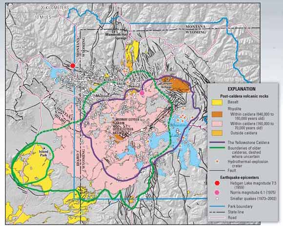
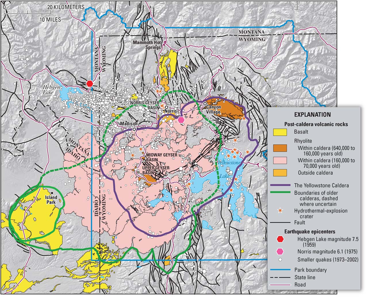
Yellowstone is home to one of the world’s largest active volcanic systems. Cataclysmic eruptions in the past few million years created huge volcanic depressions called “calderas.” The youngest, the Yellowstone Caldera, was formed 640,000 years ago. Since then, about 80 eruptions of rhyolite (thick, sticky lava) and basalt (more-fluid lava) have occurred. The caldera’s interior is largely covered by rhyolites, most erupted in the past 160,000 years. Large hydrothermal (steam)-explosion craters formed in the past 14,000 years are located near Yellowstone Lake and in major geyser basins. Recent earthquakes (1973 to 2002) were concentrated between Hebgen Lake and the Norris Geyser Basin and along faults.


Today, most of the landforms within the Yellowstone Caldera reflect the shapes of these young lava flows. Cliffs surrounding the Upper Geyser Basin near Old Faithful Geyser are the cooled steep flow fronts of once-slow-moving rhyolite lavas. Some narrow ridges and valleys on the Canyon-Norris road are corrugations on the surface of a 110,000-year-old rhyolite flow. These roughly concentric ridges formed as the thick, pasty lava slowly oozed northeastward, wrinkling its surface. Within the caldera, rivers and streams commonly occupy the gaps between individual lava flows, and springs emerge at the edges of flows.


Any renewed volcanic activity at Yellowstone would most likely take the form of such mainly nonexplosive lava eruptions. An eruption of lava could cause widespread havoc in the park, including fires and the loss of roads and facilities, but more distant areas would probably remain largely unaffected.


Photo of volcanic cliff with road beneath it and meadow in the foreground


Since its last cataclysmic volcanic eruption 640,000 years ago, the Yellowstone region has had about 40 eruptions of slow-moving lava flows of rhyolite (a variety of molten rock that is thick and sticky). Some of these flows cover more than 100 square miles, and many are very thick, like this approximately 180,000-year-old rhyolite flow exposed at Obsidian Cliff. Although no lava has been erupted at Yellowstone for 70,000 years, future such eruptions are likely to occur. (USGS photograph by Robert Christiansen.)


Earthquakes


From 1,000 to 3,000 earthquakes typically occur each year within Yellowstone National Park and its immediate surroundings. Although most are too small to be felt, these quakes reflect the active nature of the Yellowstone region, one of the most seismically active areas in the United States. Each year, several quakes of magnitude 3 to 4 are felt by people in the park.


Although some quakes are caused by rising magma and hot-ground-water movement, many emanate from regional faults related to crustal stretching and mountain building. For example, major faults along the Teton, Madison, and Gallatin Ranges pass through the park and likely existed long before the beginning of volcanism there. Movements along many of these faults are capable of producing significant earthquakes.
The most notable earthquake in Yellowstone’s recent history occurred in 1959. Centered near Hebgen Lake, just west of the park, it had a magnitude of 7.5. This quake caused $11 million in damage (equivalent to $70 million in 2005 dollars) and killed 28 people, most of them in a landslide that was triggered by the quake.


Geologists conclude that large earthquakes like the Hebgen Lake event are unlikely within the Yellowstone Caldera itself, because subsurface temperatures there are high, weakening the bedrock and making it less able to rupture. However, quakes within the caldera can be as large as magnitude 6.5. A quake of about this size that occurred in 1975 near Norris Geyser Basin was felt throughout the region.


Even distant earthquakes can affect Yellowstone. In November 2002, the magnitude 7.9 Denali Fault earthquake struck central Alaska, 1,900 miles (3,100 km) northwest of Yellowstone. Because this quake’s energy was focused toward the active Yellowstone volcanic and hydrothermal system, it triggered hundreds of small earthquakes there. The region’s hydrothermal system is highly sensitive to quakes and undergoes significant changes in their wake. Earthquakes may have the potential to cause Yellowstone’s hot-water system to destabilize and produce explosive hydrothermal eruptions.


EARTHQUAKES IN THE YELLOWSTONE REGION


map of  Yellowstone showing epicenter in northwest just outside the park on the Montana side


The Yellowstone National Park region produces about 2,000 earthquakes each year. Most of these quakes are too small to be felt, but they reflect the active nature of the region, one of the most seismically active areas in the United States.


The most powerful earthquake in Yellowstone’s recent history occurred in 1959. This quake was centered near Hebgen Lake, just west of the park, and had a magnitude (M) of 7.5. The Hebgen Lake earthquake killed 28 people-26 in a huge landslide triggered by the quake-and caused $11 million in damage (about $70 million in 2005 dollars). Numerous structures and roads in the region were severely damaged when hillsides collapsed, gaping cracks opened in the ground, and large blocks of rock were displaced.


The Hebgen Lake quake caused widespread changes in Yellowstone-roads were closed throughout the area, some geysers stopped erupting, and others were newly formed or came back to life after years of dormancy. Also, the Old Faithful Inn was strongly shaken-pipes broke, a chimney collapsed, and the inn had to be evacuated.


Although quakes of this magnitude are rare in the Yellowstone region, they are certain to occur in the future. To better understand this hazard and help protect the public, scientists of the Yellowstone Volcano Observatory (YVO) continually monitor the region’s seismic activity.


Photograph of house nearly submerged with broken-off road in foreground and landslide cliff in background


This house fell into Hebgen Lake during the 1959 earthquake and floated along the shore until it came to rest here. The owner of the house, then-70-year-old Mrs. Grace Miller, escaped only after kicking out her front door and leaping a 5-foot-wide ground crack as her house dropped into the lake. (USGS photograph by J.B. Hadley.)


illustration of seismogram showing small background wiggles and large shock wiggles in the middle


Seismogram of the 1959 magnitude 7.5 Hebgen Lake earthquake recorded at Butte, Montana, about 100 miles from the epicenter.


Hydrothermal Explosions


The large magma reservoir beneath Yellowstone may have temperatures higher than 1,475°F (800°C), and the surrounding rocks are heated by it. Because of this, the average heat flow from the Earth’s interior at Yellowstone is about 30 times greater than that typical for areas elsewhere in the northern Rocky Mountains. As snowmelt and rainfall seep deep into the ground, they can absorb enough of this heat to raise the temperature of the ground water close to the boiling point. Geyser basins and other thermal areas in Yellowstone National Park are places where hot ground water has risen close to the surface. Research drilling at Yellowstone in the 1960s confirmed that the ground water beneath many of the park’s thermal areas is very hot. At Norris Geyser Basin, water temperatures as high as 460°F (238°C) were recorded at depths of only 1,090 feet (332 m).


Because the boiling point of water increases with increasing pressure and pressure increases with depth, deep water can be hotter than boiling water near the surface. If the pressure that confines this deep water is reduced quickly, pockets of water may suddenly boil, causing an explosion as the water is converted to steam. Such activity drives the eruptions of geysers, like Old Faithful, which are repetitive releases of plumes of steam and water. Rarely, steam explosions are more violent and can hurl water and rock thousands of feet. In Yellowstone’s geologic past, such violent events, called “hydrothermal explosions,” have occurred countless times, creating new landscapes of hills and craters.


A recent and notable hydrothermal explosion occurred in 1989 at Porkchop Geyser in Norris Geyser Basin. The remains of this explosion are still clearly visible today as an apron of rock debris 15 feet (5 m) across surrounding Porkchop’s central spring. In the 1880s and early 1890s, a series of powerful hydrothermal explosions and geyser eruptions occurred at Excelsior Geyser in the Midway Geyser Basin. Some of the explosions hurled large rocks as far as 50 feet (15 m).


Much larger hydrothermal explosions have occurred at Yellowstone in the recent geologic past. More than a dozen large hydrothermal-explosion craters formed between about 14,000 and 3,000 years ago, triggered by sudden changes in pressure of the hydrothermal system. Most of these craters are within the Yellowstone Caldera or along a north-south-trending zone between Norris and Mammoth Hot Springs.


The largest hydrothermal-explosion crater documented in the world is along the north edge of Yellowstone Lake in an embayment known as Mary Bay. This 1.5-mile (2.6 km)-diameter crater formed about 13,800 years ago and may have had several separate explosions in a short time interval. What specifically triggered these very large events is not firmly established, but earthquakes or a pressure release caused by melting glaciers or rapid changes in lake level may have been a significant factor.


These very large and violent hydrothermal explosions are independent of associated volcanism. None of the large hydrothermal events of the past 16,000 years has been followed by an eruption of magma. The deeper magma system appears to be unaffected even by spectacular steam explosions and crater excavations within the overlying hydrothermal system.


Although large hydrothermal explosions are a feature of Yellowstone’s recent geologic history, most explosions in historical times have been relatively small and have left craters at most a few yards across. For example, in early 2003, a long linear fissure appeared on a hillside above Nymph Lake, north of Norris Geyser Basin, venting steam and throwing bits of rock onto the surrounding hillside. Although most hydrothermal explosions in the park are small, their remains can be noticed by observant visitors and attest to the nearly continuous geologic activity at Yellowstone.


HYDROTHERMAL (STEAM) EXPLOSIONS AT YELLOWSTONE


painting showing steam explosion reaching far into the blue sky; forest in background and wet meadow in foreground


Excelsior Geyser erupted in a series of violent hydrothermal explosions in the 1880s and early 1890s; one of these eruptions is shown in this colorized postcard made from a photograph. These were the largest such events to occur in the Yellowstone region in historical times. (Original photograph by F. Jay Haynes, 1888; date on postcard is incorrect.)


Geysers and hot springs are common expressions of a hydrothermal (hot water) system, but sometimes changes in “plumbing” result in large volumes of water suddenly flashing into steam, causing violent hydrothermal explosions. A large hydrothermal explosion can hurl water and rock thousands of feet and create new landscapes of hills and craters. In Yellowstone’s geologic past, hydrothermal explosions have occurred countless times.


In 1881, Colonel Philetus W. Norris, Yellowstone National Park’s second superintendent, witnessed a spectacular hydrothermal explosion at Excelsior Geyser in the Midway Geyser Basin. He described the aftermath as follows: “The pool was considerably enlarged, its immediate borders swept entirely clear of all movable rock, enough of which had been hurled or forced back to form a ridge from knee to breast high at a distance of from 20 to 50 feet [ 6 to 15 m] from the ragged edge of the yawning chasm.” After a series of such explosions that ended in the early 1890s, Excelsior, once the world’s largest active geyser, became a quietly boiling hot spring. Except for several geyser eruptions in 1985, it has remained so ever since.


A more recent hydrothermal explosion occurred in 1989 at Porkchop Geyser in Norris Geyser Basin. The remains of this explosion are still clearly visible today as a 15-foot (5 m)-diameter apron of rock debris surrounding Porkchop’s central spring.


Much larger hydrothermal explosions have occurred at Yellowstone in the recent geologic past. The greatest concentration of hydrothermal-explosion craters lies around the north end of Yellowstone Lake. These craters owe their origins to spectacular explosions thousands of years ago.


old black-and-white photograph of gray-bearded old man dressed in buckskins leaning on his lever-action Winchester Model 73 carbine (rifle).  Backdrop of clouds and valley and foreground of rocks and brush appear to be studio props.


Colonel Philetus W. Norris was Yellowstone National Park’s second superintendent (1877 to 1882). A decorated Civil War Union veteran, Norris enjoyed challenges, and his efforts were essential in putting the park’s management on a sound footing. (Photograph courtesy of the National Park Service.)


Recent color photograph of black-bearded young man dressed in park-service uniform leaning on broken boulder.  Backdrop of steam  and foreground of rocks are real.>


Yellowstone National Park research geologist Rick Hutchinson examines rock debris thrown out in a 1989 hydrothermal explosion at Porkchop Geyser. [In March 1997, Hutchinson was killed in a snow avalanche while on duty inspecting thermal features in the park.] (Photograph courtesy of Robert Smith, University of Utah.)


PREHISTORIC CALDERA-FORMING ERUPTIONS OF YELLOWSTONE


Map of United States showing small ash deposit for Mt. St. Helens covering only parts of two states compared to large ash deposits from Yellowstone and Long Valley covering half the country.


Eruptions of the Yellowstone volcanic system have included the two largest volcanic eruptions in North America in the past few million years; the third largest was at Long Valley in California and produced the Bishop ash bed. The biggest of the Yellowstone eruptions occurred 2.1 million years ago, depositing the Huckleberry Ridge ash bed. These eruptions left behind huge volcanic depressions called “calderas” and spread volcanic ash over large parts of North America (see map). If another large caldera-forming eruption were to occur at Yellowstone, its effects would be worldwide. Thick ash deposits would bury vast areas of the United States, and injection of huge volumes of volcanic gases into the atmosphere could drastically affect global climate. Fortunately, the Yellowstone volcanic system shows no signs that it is headed toward such an eruption in the near future. In fact, the probability of any such event occurring at Yellowstone within the next few thousand years is exceedingly low.


Close-up photograph of person's hands holding half a cup of rock flour


Volcanic ash, like this ash from the 1980 eruption of Mount St. Helens, is made up of tiny jagged particles of rock and glass. Even a light dusting of volcanic ash can pose a health hazard to people and animals and damage crops, electronics, and machinery. Heavy ash fall, such as that from a large caldera-forming eruption, would devastate the surrounding area and affected areas downwind.


image from scanning electron microscope showing ash particle having the texture of lacy Swiss cheese


Ash particle magnified about 200 times. (USGS photographs.)


How Big Were the Yellowstone Eruptions?


Drawing of nine ash clouds and nine stylized spheres underground showing how much more massive Yellowstone's prehistoric erruptions were than 19th- and 20th-centrury eruptions


Explosive eruptions are best compared by recalculating the volume of erupted volcanic ash and pumice (see photos) in terms of the original volume of molten rock (magma) released (shown in this diagram by orange spheres). On this basis, the 585 cubic miles (mi3) of magma that was erupted from Yellowstone 2.1 million years ago (Ma) was nearly 6,000 times greater than the volume released in the 1980 eruption of Mount St. Helens, Washington, which killed 57 people and caused damage exceeding $1 billion. Even the 1815 Tambora, Indonesia, eruption—the largest on Earth in the past two centuries—was more than five times smaller than the smallest of Yellowstone’s three great prehistoric eruptions at 1.3 Ma.


HAZARDOUS EVENTS AT YELLOWSTONE


Set of four drawings showing hydrothermal explosions (frequent -several to many per century- but less destructive) on the left, caldera-forming eruptions (infrequent -1 or 2 per million years- but more destructive) as the two extremes.  In the middle between the end members are strong earthquakes (one to several per century) and lava flows (about 100 per million years)


Scientists evaluate natural-hazard levels by combining their knowledge of the frequency and the severity of hazardous events. In the Yellowstone region, damaging hydrothermal explosions and earthquakes can occur several times a century. Lava flows and small volcanic eruptions occur only rarely—none in the past 70,000 years. Massive caldera-forming eruptions, though the most potentially devastating of Yellowstone’s hazards, are extremely rare—only three have occurred in the past several million years. U.S. Geological Survey, University of Utah, and National Park Service scientists with the Yellowstone Volcano Observatory (YVO) see no evidence that another such cataclysmic eruption will occur at Yellowstone in the foreseeable future. Recurrence intervals of these events are neither regular nor predictable.


How Dangerous Is Yellowstone?


None of the events described above—cataclysmic caldera-forming eruptions, lava flows, large earthquakes, or major hydrothermal explosions—are common in Yellowstone. Although visitors to Yellowstone National Park may never experience them, some hazardous events are certain to occur in the future. Fortunately, systematic monitoring of Yellowstone’s active volcanic and hydrothermal systems, including monitoring of earthquakes and ground deformation, is now carried out routinely by YVO scientists. This monitoring will allow YVO to alert the public well in advance of any future volcanic eruptions. Currently the ability to reliably predict large quakes or hydrothermal explosions, events more likely than a volcanic eruption, remains a challenge. However, changes in the patterns of ongoing seismicity or other indicators of possible geologic unrest are quickly reported to officials responsible for public safety in the National Park Service and other agencies.


Through continuous monitoring and research, YVO is greatly improving understanding of Yellowstone’s volcanic, earthquake, and hydrothermal hazards. The work of USGS scientists with YVO is only part of the USGS Volcano Hazards Program’s ongoing efforts to protect people’s lives and property in all of the volcanic regions of the United States, including California, Hawaii, Alaska, and the Pacific Northwest.


THE YELLOWSTONE VOLCANO OBSERVATORY


Increased scientific surveillance of Yellowstone in the past 30 years has detected unmistakable changes in its vast underground volcanic system, similar to historical changes observed at many other large calderas (volcanic depressions) in the world. To strengthen the capabilities of scientists to track and respond to changes in Yellowstone’s activity, a fifth U.S. volcano observatory was created in 2001, complementing existing ones for Hawaii, Alaska, the Cascades, and Long Valley, California. The Yellowstone Volcano Observatory (YVO) is supported jointly by the U.S. Geological Survey, the University of Utah, and Yellowstone National Park.


The principal goals of YVO include:

  • Strengthening the monitoring system for tracking earthquake activity, uplift and subsidence, and changes in the hydrothermal (hot water) system;

  • Assessing the long-term potential hazards of volcanism, earthquakes, and explosive hydrothermal activity in the Yellowstone region;

  • Enhancing scientific understanding of active geologic and hydrologic processes occurring beneath Yellowstone and in the surrounding region of the Earth’s crust; and

  • Communicating new scientific results, the current status of Yellowstone’s activity, and forecasts of potential hazardous hydrothermal explosions or volcanic eruptions to Yellowstone National Park staff, the public, and local, State, and Federal officials. Current real-time-monitoring data are online at http://volcanoes.usgs.gov/yvo/monitoring.html.


    logo of YVO showing map and geyser


    By
    Jacob B. Lowenstern, Robert L. Christiansen, Robert B. Smith, Lisa A. Morgan, and Henry Heasler


    Edited by Peter H. Stauffer and James W. Hendley II

    Graphic design by Susan Mayfield and Sara Boore

    Web design by Michael Diggles

    Banner design by Bobbie Myers


    COOPERATING ORGANIZATIONS


    Yellowstone National Park


    University of Utah


    Source: http://pubs.usgs.gov/fs/2005/3024/

  •